
Overview
In addition, the early departures offer long days, up to 24 hours of daylight in July, while the late August and early September departures bring darkness and with that the chance to see the Northern Lights.
Itinerary
After a Flybus transfer to our hotel, we begin with a briefing from the leader, usually at 6. 30pm. Here you receive an outline of the week ahead and have the chance to ask any questions. After, our groups typically go out for dinner together.
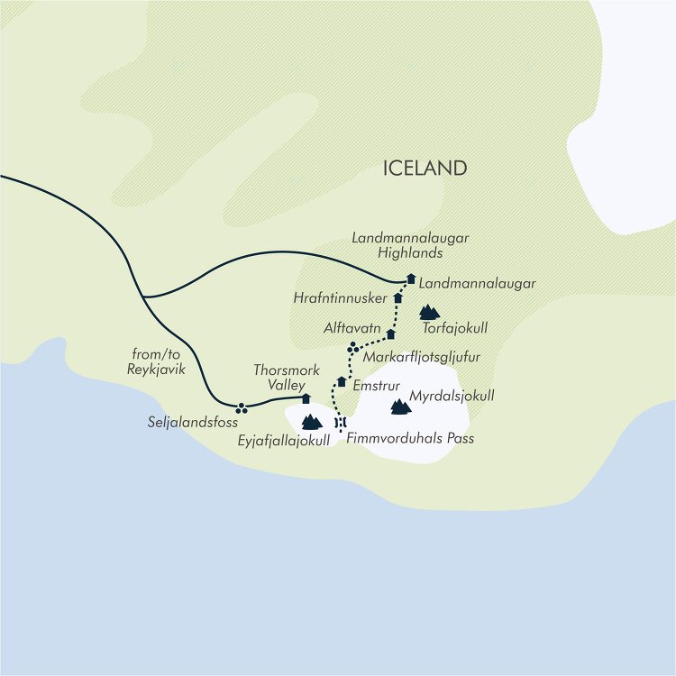
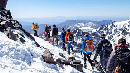
We transfer up to the unmistakable Landmannalaugar mountains. The drive will take approximately four hours as we head through the south of Iceland, up the Thjorsardalur valley towards Mount Hekla, an enormous volcano responsible for enormous destruction in centuries past. Here, we turn into the Highlands and the black volcanic desert of the Fjallabak area. The Fjallabak Nature Reserve is one of the most popular areas in Iceland for trekking with a landscape like nowhere else, from black volcanic plains to multicoloured rhyolite mountains.
At the heart of all this are the Landmannalaugar mountains, where we pitch our camp before having lunch. Typically, most trips begin the Laugavegur Trail today; however, we take the opportunity to enjoy a daywalk in these unique surroundings. Our afternoon walk heads to the top of Blue Peak and across the black Laugahruna lava field. The hot pools originate in this lava field, which was created in 1477, the last known eruption in the area. This area is believed to be the southern end of the Bardarbunga volcanic system.
The last eruption in the Bardarbunga system was a fissure eruption in the northern end from 2014 to 2015. Some 93mi (150km) north of Landmannalaugar, it was the largest eruption in Iceland for more than 200 years, though luckily did not have the same impact on air travel as the more famous Eyafjallajokull eruption of 2010. Our guide will prepare the evening meal in our mess tent, though group members are expected to pitch in and help with food preparation and washing up (B/L/D).
For the next two days, we cross the Torfajokull volcanic area (rhyolitic stratovolcano), which was formed by a series of subglacial volcanic eruptions. It is the largest rhyolitic area in Iceland, consisting of rolling rhyolite hills with numerous hot springs and sulphur vents. We start by crossing the Laugahraun lava field to the slopes of Brennisteinsalda, known for its photogenic spectrum of colours.
We take a short but very worthwhile detour to the top. En route we pass the Storihver hot spring, cross the high plateau and enter the Hrafntinnusker area. Here steam rises from hundreds of vents and our route passes numerous hot springs along the way. From Hrafntinnusker and across the Torfajokull Massif – the route meanders southwards and we hike past steaming hot springs and boiling mud pools before we start dropping down Jokultungur to the black volcanic plains west of the Myrdalsjokull glacier.
The view is spectacular on a clear day with Myrdalsjokull and Eyjafjallajökull glaciers in the foreground and the black volcanic landscape between. We enter a totally different landscape of Palagonite ridges and peaks with black volcanic plains and big glacier rivers all around. Our aim for the day is Alftavatn lake where we pitch our tents once more (B/L/D).
We head further south towards Myrdalsjokull ice cap across the black volcanic landscape. There are several rivers in this area, the largest are bridged but the smaller ones are not. We make a detour just before we make it to our destination of the day, Emstrur, heading west for the Markarfljotsglufur canyon. The Markarkfljot glacial river has cut this canyon nearly 655ft (200m) deep and it is worth a visit. After the canyon, we have a short distance to Botnar in the Emstrur area, a small green oasis in the black volcanic desert (B/L/D).
We start the day by crossing the bridge over the Emstrur River on our way to Thorsmork. We hike along the western edge of the Myrdalsjokull Ice Cap and leave the pitch-black volcanic area. Vegetation increases slowly and, eventually, we get to the lush birch-covered area of Thorsmork (Thor's woodland). Thorsmork valley is a beautiful place with magnificent glaciers, a river and wind-swept mountains. This area has been a favourite with local walkers for decades and it's easy to see why. We hike across the Thorsmork valley and over the Krossa glacial river (by bridge) and to our camp in Basar (B/L/D).
Today we pack up ready to head back to Reykjavik. Before returning to the city, we go for a hike on Solheimajokull, an outlet glacier extending from the Myrdalsjokull icecap. We explore this wonderland of ice sculptures, crevasses, and long, narrow ridges. We strap on the crampons and get the ice axes before making our way up this massive ice flow. After the glacier walk, en route to Reykjavik we stop at Skogarfoss and Kvernufoss, two particularly photogenic waterfalls.
On arrival in Reykjavik, we can check in and then head out for our final meal together. The leader can recommend or book a restaurant for the group (B).
Those wishing to spend extra time in Reykjavik will find it time well spent as this busy city has plenty to offer, from the Harpa Concert Hall to the many restaurants and cafés, not forgetting the geothermal baths, a key part of Icelandic culture (B).
Trip Inclusions
- Take the best-known trekking route in Iceland
- Discover natural hot pools, waterfalls, lava fields, craters and volcanic fissures
- Experience 24-hour daylight in July, chance of the Northern Lights in late August and September
- Two hotel nights, four nights of participatory camping
- Three full and two half days of walking
- Low altitude throughout
- All breakfasts, four lunches and four dinners
- All transport and listed activities
- Tour leader from meeting at hotel on Day 1 to the end of Day 6
- Glacier walk on Day 6
- Airport shuttle bus transfers for everyone
- Itinerary and inclusions are subject to change
- Price is for land, cruise and internal flights as specified. Flights not specified are not included
Hit the trails with Exodus - from challenging peaks to leisurely coastal and countryside walks. Read more
Exodus chooses their Leaders carefully. Professional, dedicated and are passionate about sharing their home countries. Read more
Wherever possible, Exodus chooses properties that are locally owned and that reflect the area you are visiting. Read more
Availability
A definite departure means minimum numbers have been reached for this departure to operate. Your Global Journeys Travel Advisor will check the availability of your departure date when you enquire. Additional savings may apply. We guarantee the lowest price in Australia. T&C’s apply.
Tour & cruises prices are per person. Prices shown have savings applied, are subject to availability and may be withdrawn at any time without notice. Prices and trip information are correct at the time at this point in time, however are subject to confirmation at the time of booking and are subject to change by Exodus. For cruise itineraries, cabin images are sourced from Exodus. These should be treated as indicative only. Cabin inclusions, upholsteries and room layout may differ to the image(s) shown depending on the ship selected and your sailing dates.